Road infrastructure is one of the most critical components of any developing or developed nation. Yet, potholes remain one of the most persistent and dangerous problems affecting road safety, vehicle health, and traffic efficiency. From minor discomfort to major accidents, potholes can cause significant damage both economically and socially. Traditional methods of detecting and reporting potholes rely heavily on manual inspection or citizen complaints, which are often slow, inconsistent, and inefficient.
To address this challenge, I developed an AI-Based Pothole Detection System — a comprehensive, intelligent solution that automates pothole detection, measurement, classification, and reporting using modern computer vision and machine learning techniques. This system not only detects potholes in real-time but also generates structured reports that can be directly shared with government authorities, enabling faster and more efficient road maintenance decisions.
The Problem with Traditional Road Monitoring
Conventional road inspection methods involve manual surveys, physical inspections, or reactive complaint systems. These approaches have several limitations. They are time-consuming, prone to human error, and lack scalability. In many cases, potholes go unnoticed until they become severe hazards.
Moreover, even when potholes are reported, there is often a lack of structured data. Authorities may receive complaints without precise location, size, or severity details, making prioritization difficult. This results in delayed repairs, inefficient resource allocation, and increased risk to commuters.
There is a clear need for an automated, scalable, and intelligent system that can continuously monitor road conditions and provide actionable insights.
Vision Behind the System
The goal of this project is to transform road maintenance from a reactive process into a proactive, data-driven system. By leveraging artificial intelligence and computer vision, the system aims to:
- Detect potholes automatically from road videos
- Count and track unique potholes accurately
- Measure pothole dimensions for severity assessment
- Map pothole locations using GPS data
- Generate professional reports for authorities
- Enable direct communication with government bodies
Ultimately, the system bridges the gap between detection and action, ensuring that identified problems are communicated effectively and resolved faster.
System Overview
The AI-Based Pothole Detection System is built as an end-to-end solution that integrates deep learning, data processing, visualization, and reporting into a single workflow.
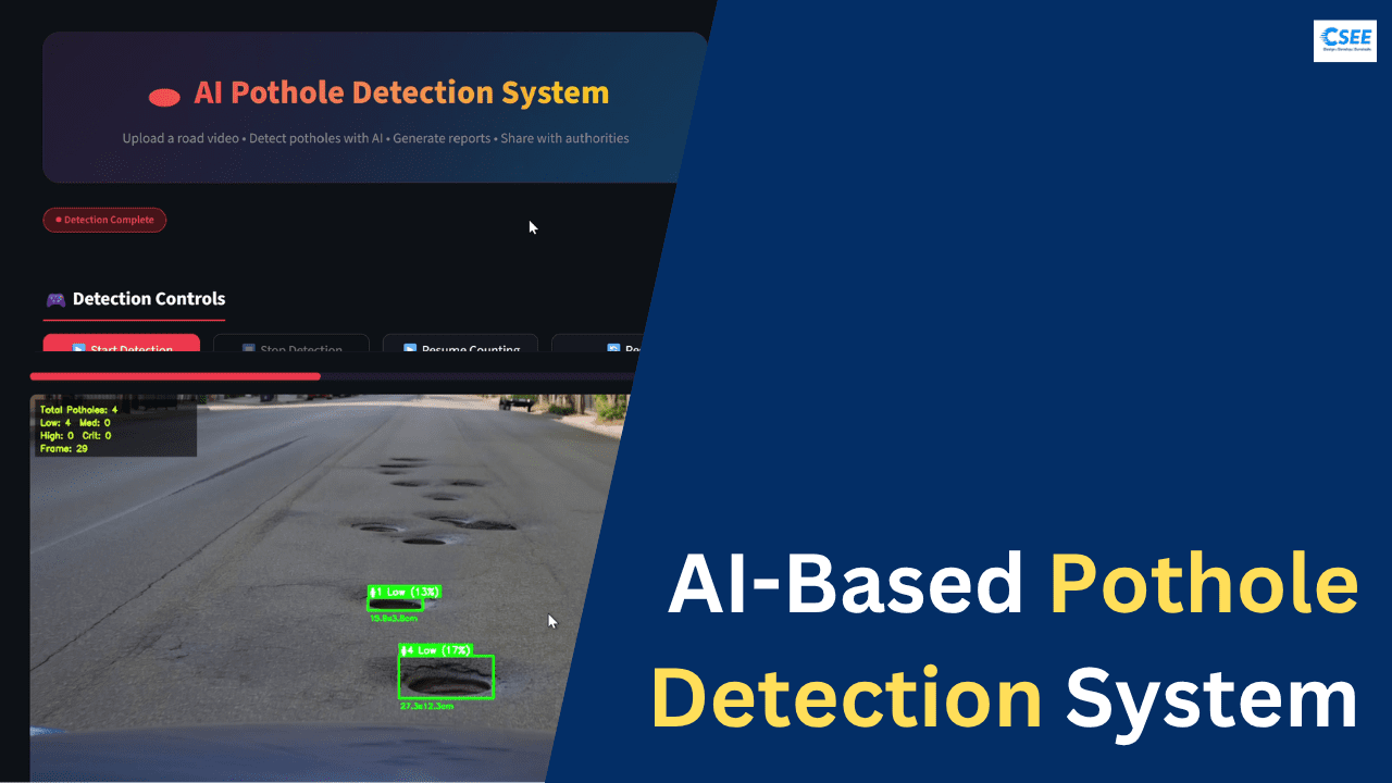
Users can upload a dashcam video or road survey footage, and the system processes it frame by frame. Using a trained AI model, potholes are detected, tracked, and analyzed in real time. The results are then visualized through an interactive dashboard and compiled into detailed reports.
What makes this system powerful is not just detection, but the complete lifecycle — from identifying potholes to generating actionable reports and enabling communication with authorities.
Key Features
The system includes a wide range of features designed to make pothole detection and reporting efficient and user-friendly.
The AI detection module is powered by YOLOv8, which enables real-time object detection with high accuracy. It can identify potholes from both images and videos, making it suitable for various use cases such as dashcams, survey vehicles, and drone footage.
Smart counting ensures that each pothole is counted only once, even if it appears in multiple frames. This is achieved through a deduplication mechanism that tracks pothole positions across frames.
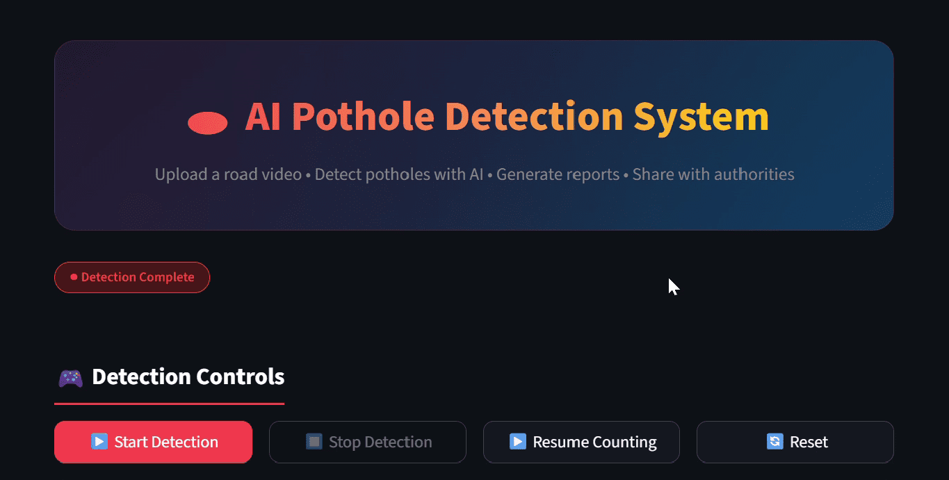
Users have full control over the detection process with start, pause, and stop functionalities. This allows flexibility in analyzing long videos or focusing on specific sections of interest.
The system also estimates pothole size in real-world units such as centimeters. By converting pixel measurements using a calibration ratio, it provides meaningful physical dimensions.
Based on size and area, potholes are classified into severity levels such as low, medium, high, and critical. This classification helps in prioritizing repairs effectively.
An interactive dashboard presents the results visually through charts, timelines, and scatter plots. Users can easily explore trends and patterns in the detected data.
GPS mapping enables potholes to be plotted on interactive maps, providing geographical context and making it easier for authorities to locate them.
The system generates professional PDF reports that include summaries, detailed data, and recommendations. Additionally, users can export data in CSV or Excel formats for further analysis.
One of the most impactful features is the ability to send reports directly to government authorities via email. The system can also generate formal complaint letters automatically, reducing the effort required for reporting issues.
A detection gallery stores visual evidence of potholes, which can be included in reports as proof. The modern dark-themed UI ensures a smooth and visually appealing user experience.
System Architecture
The project is structured in a modular way to ensure scalability and maintainability. Each component is responsible for a specific function within the system.
The main application is built using Streamlit, which serves as the user interface. It handles user inputs, displays results, and manages the overall workflow.
The detection engine is implemented using YOLOv8 and PyTorch. It processes video frames and identifies potholes with bounding boxes and confidence scores.
The report generation module compiles detection data into structured formats such as PDF, CSV, and Excel. It ensures that the output is professional and easy to interpret.
Utility modules handle tasks such as email sending and complaint letter generation. Configuration files allow users to customize system parameters without modifying the core code.
The project also includes directories for storing input videos, output reports, detected frames, and model weights, ensuring organized data management.
Technology Stack
The system leverages a powerful combination of technologies to achieve its functionality.
YOLOv8 is used for object detection due to its speed and accuracy. It enables real-time processing, which is essential for handling video data efficiently.
PyTorch serves as the deep learning framework, providing flexibility and performance for model training and inference.
OpenCV is used for video processing, frame extraction, and image manipulation. It plays a crucial role in preparing data for the AI model.
Streamlit is used to build the web-based dashboard, allowing users to interact with the system بسهولة and without complex setup.
Plotly is used for creating interactive charts and visualizations, making it easier to analyze data.
Folium is used for map visualization, enabling geographic representation of pothole locations.
FPDF2 is used for generating PDF reports, while Pandas handles data processing and analysis.
How the System Works
The workflow begins when the user uploads a road video or selects one from the input directory. The system reads the video and processes it frame by frame.
Each frame is passed through the YOLOv8 model, which detects potholes and returns bounding boxes along with confidence scores. These detections are then filtered based on a confidence threshold to ensure accuracy.
To avoid counting the same pothole multiple times, the system uses a deduplication mechanism based on spatial proximity. If a detected pothole is within a certain radius of a previously detected one, it is considered the same object.
The size of each pothole is estimated by converting pixel dimensions into real-world units using a predefined ratio. Based on this size, the system assigns a severity level.
If GPS data is provided, the system associates each detection with geographical coordinates. This allows potholes to be plotted on a map.
Once the video processing is complete, the system compiles all the data into structured formats. It generates visualizations, summaries, and detailed tables.
Finally, a comprehensive report is created, which can be downloaded or sent directly to authorities.
Reporting and Government Integration
One of the most important aspects of this system is its ability to generate actionable reports. The generated PDF includes an executive summary, total pothole count, severity distribution, and detailed measurements of each pothole.
The report also includes recommendations, such as prioritizing critical potholes for immediate repair. This helps authorities allocate resources more effectively.
In addition to reports, the system can generate formal complaint letters that can be submitted to municipal authorities. This reduces the effort required for citizens to report issues.
The email integration feature allows users to send reports directly to government departments. This creates a seamless pipeline from detection to action.
By enabling structured communication, the system ensures that pothole data is not just collected but also utilized effectively.
Real-World Applications
This system can be used in multiple real-world scenarios. Municipal corporations can use it for routine road inspections and maintenance planning.
Transportation departments can deploy it in survey vehicles to continuously monitor road conditions.
Logistics and fleet companies can use it to assess road quality and optimize routes.
Smart city initiatives can integrate this system to enhance urban infrastructure management.
Even individual users can contribute by recording road videos and generating reports, creating a crowdsourced approach to road maintenance.
Benefits of the System
The AI-Based Pothole Detection System offers numerous benefits. It significantly reduces the time and effort required for road inspection.
It provides accurate and consistent data, eliminating human error. The use of AI ensures scalability, allowing large areas to be monitored efficiently.
The system improves road safety by enabling faster detection and repair of potholes. It also supports data-driven decision-making, helping authorities prioritize repairs based on severity and impact.
By automating the reporting process, it bridges the gap between problem identification and resolution.
Future Enhancements
While the current system is highly capable, there are several opportunities for future improvements.
Real-time integration with dashcams or live camera feeds can make the system even more powerful. A mobile application can make it accessible to a wider audience.
Cloud deployment can enable large-scale processing and centralized data management. Integration with government APIs can automate the reporting process further.
Advanced features such as road quality scoring, predictive maintenance, and historical trend analysis can provide deeper insights.
Conclusion
The AI-Based Pothole Detection System represents a significant step toward smarter and safer road infrastructure. By combining artificial intelligence, computer vision, and data analytics, it transforms the way potholes are detected, analyzed, and reported.
From real-time detection to automated reporting and government communication, the system provides a complete solution to a persistent problem. It empowers both authorities and citizens to take proactive action and improve road conditions.
As cities continue to evolve into smart ecosystems, solutions like this will play a crucial role in building efficient, safe, and sustainable infrastructure.
Source code: https://drive.google.com/file/d/1XLwk5KQ6VlJloJKh9uyKH0Zgro7g0N17/view?usp=sharing
Also, read:
- Highest-Paying Career Fields for EEE & ECE Engineers in 2026
- Embedded Engineer To AI Engineer Roadmap
- India’s First Private Orbital Rocket: How Skyroot Aerospace’s Vikram-1 Is Transforming the Future of India’s Space Industry
- Visually Explained MAAB / MAB Modeling Guidelines
- Visually Explained MISRA Guidelines
- Visually Explained Processor-In-The-Loop Testing, PiL Testing
- Visually Explained Software-In-The-Loop Testing, SiL Testing
- Visually Explained Model-In-Loop Testing, MiL Testing